Introduction
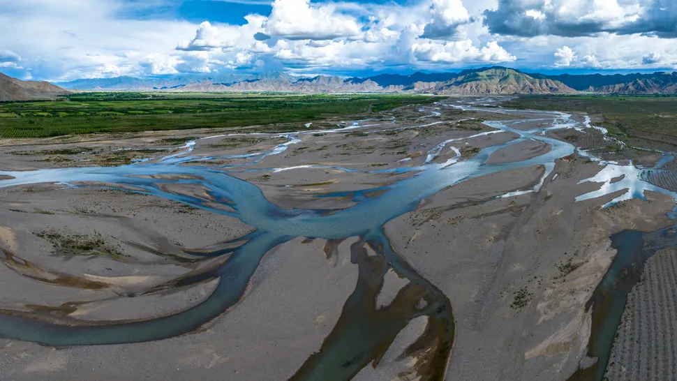
High above sea level, where the thin air meets the peaks of the Tibetan Plateau, flows the Yarlung Zangbo River — the world’s highest major river. Stretching over 2,000 kilometers (1,250 miles), this river is not just remarkable for its altitude but for its ever-changing form. A recent Landsat 9 image taken on February 8, 2025, reveals a mesmerizing mosaic of shifting channels — a textbook example of a braided river system in action.
The Science Behind the Image
Captured by NASA’s Landsat 9, the photo highlights a section of the river in Zhanang County, Tibet, just upstream of the Yarlung Tsangpo Grand Canyon — the deepest land canyon on Earth, plunging more than 6,000 meters (20,000 feet), nearly three times deeper than the Grand Canyon in the U.S.
This region’s “braided” pattern consists of multiple interweaving channels that split, merge, and reshape with every season. According to NASA’s Earth Observatory, the river flows at an average altitude of 4,000 meters (13,000 feet) above sea level — making it not just the highest, but one of the most dynamic rivers on the planet.
Why the River “Braids”
The Yarlung Zangbo’s spectacular braiding is the result of:
-
High sediment load – Massive deposits from the nearby Himalayas flow into the river during the monsoon season.
-
Variable discharge – Melting glaciers and seasonal rains constantly alter the river’s flow rate.
-
Steep gradient – The elevation drop accelerates erosion, carving new channels through soft sediments.
-
Weak vegetation cover – Because sandbars form and vanish quickly, no roots can stabilize the soil.
“The river changes shape so often that no vegetation can fully grow on its sandbars,” explains Zoltán Sylvester, geologist at the University of Texas at Austin.
Climate Change and Instability
Climate models suggest that melting glaciers and intensified rainfall will further increase the Yarlung Zangbo’s instability. This could lead to:
-
More extreme flooding events,
-
Accelerated sedimentation, and
-
Greater erosion of riverbanks and valleys downstream.
Such transformations threaten both local ecosystems and downstream communities in India and Bangladesh, where the river becomes the Brahmaputra.
Earth from Space: A Living Laboratory
For scientists, the Yarlung Zangbo is an open-air experiment — a living system where hydrology, climate, and geology interact in visible, measurable ways. Remote sensing tools like Landsat 9 and Sentinel-2 now allow researchers to track the evolution of river channels, quantify sediment loads, and forecast landscape changes with unprecedented precision.

Key Facts Recap
| Attribute | Details |
|---|---|
| Name | Yarlung Zangbo River |
| Location | Tibet Autonomous Region, China |
| Coordinates | 29.2814°N, 91.3256°E |
| Average Elevation | ~4,000 m (13,000 ft) |
| Length | ~2,000 km (1,250 miles) |
| Canyon Depth | >6,000 m (20,000 ft) |
| Satellite | NASA’s Landsat 9 |
| Image Date | February 8, 2025 |
Why It Matters
The Yarlung Zangbo is more than a geological wonder — it’s a climate barometer for Asia’s “Water Tower.” Changes here can signal broader hydrological shifts affecting over a billion people who depend on Himalayan-fed rivers.
This image, beyond its beauty, is a warning from the planet: as the climate warms, even the most remote rivers are rewriting their maps.
Acknowledgments
This article draws on data and imagery from NASA’s Earth Observatory and the Landsat 9 mission, whose open-access Earth observation archives enable scientists and educators to explore planetary change in real time.
Special thanks to:
-
Harry Baker, Science Writer at Live Science, for his insightful reporting on global geomorphological phenomena.
-
Zoltán Sylvester, Geologist at the University of Texas at Austin, for expert commentary on sediment dynamics and braided river morphology.
-
The U.S. Geological Survey (USGS) maintains Landsat mission archives.
-
The National Park Service (NPS) has publicly available geomorphological definitions that enrich public understanding of braided river systems.
This analysis was interpreted and curated by Collins Odhiambo Owino for DatalytIQs Academy under the Earth & Environmental Analytics series — a platform dedicated to connecting scientific imagery, climate data, and real-world applications in education.
Leave a Reply
You must be logged in to post a comment.